
PROBLEMATICS
 Every time there are more common the cases of environmental pollution provoked in our cities due to soils contaminated with the parks of storage, the service stations, escapes in pipelines of land, escapes in big pipelines of unload, perforations in warehouses, uncontrolled spillages of garbage, spillages in industrial plants and pipelines of hydrocarbons.
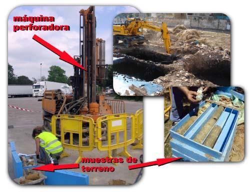
To create a system of cleanliness implies taking a high degree of accuracy of which it is the pollution source, physical and chemical characteristics of the pollutant element, surface, volume, direction and speed of displacement. Once there are known by accuracy the parameters that characterize the pollutant factor, it is when it is possible to initiate with the tasks of decontamination. Nowadays, the labores of evaluation of a contaminated area, is in the habit of being very aggressive with the area due to the need to effect polls by means of excavations and perforations to take samples of the area.
SOLUTION.
The employment of different geophysical methods allows us a wide interpretation of the pollution, reducing the number of points of sampling, to design a strategy of recovery and more effective cleanliness. This means a significant saving to the moment to quantify the degree of pollution minimizing the number of polls. In RAFIBRA we possess the most rapid, economic systems, modern and advanced to effect the analysis of the different contaminated areas that would imply knowing with major precision the parameters of the pollutant and everything without realizing any type of excavation, poll or calicata in the zone to evaluating.
AIR INFRARED PHOTOGRAPHY.
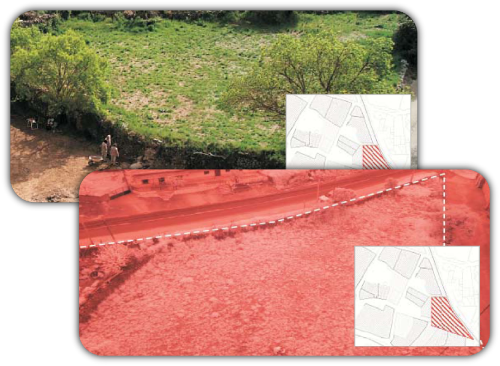 With the utilization of the infrared aerial photography and of visible spectrum of areas, it is possible to check the presence of not visible pollution caused by warehouses, ditches, architectural structures, etc. In the subsoil and his spatial positioning. The above mentioned system allows to visualize anomalies under the subsoil and his precise positioning of a rapid and economic form that wraps thousands of square meters in every photography.
PHOTOGRAPHY INFRARED THERMAL IMAGING.
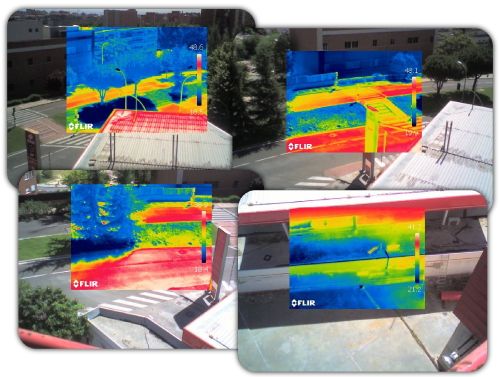 The technology consists of the execution of a series of photographies across a digital chamber thermos graph of the area to evaluating. This infrared chamber is capable of detecting any structure / anomaly that is located under the subsoil providing that they have certain entity, and visualizes them across contrasts of these elements in the superficial caps of area and his impact in the surface. The above mentioned superficial variations regularly are not visible in the spectrum of visible light, but in the infrared one they are revealed, in certain contexts.
Thermal Desigualdades in the soil can be an indicator of the presence in the subsoil of diverse geomorphologic structure. When exists a stratum of different density, as the hydrocarbons, a variation is detected in the temperature of the soil in these zones. The existence of hydrocarbons in the surface and / or shallow levels delays the thermal dissipation and always it increases considerably the residual temperature
DIELECTRIC SPACE SYSTEM.
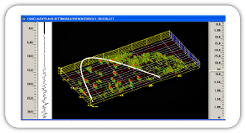 The Space System Dieléctric is a geophysical not destructive technology that consists of the emission and receipt of electromagnetic waves of the soil supplying an image of the subsoil calculating differences in the electromagnetic properties of the materials.
FUNCTIONING OF THE SYSTEM.
To effect the detection and spatial positioning of pollution by hydrocarbons in the subsoil, the following procedures are realized:
- Capture of information in situ by means of radargramas linear. For this method the GEORADAR is in use with antenna fitted in a car endowed of odómetro.
- Accused of the information obtained in the fieldwork and generation of map of pollution.
ADVANTAGES OPPOSITE TO POLLS.
- RAFIBRA-GEORADAR is a not invasive method, that is to say, it does not need to effect excavations or any type of destructive intervention of the area. · Is a method that does not disturb the environment.
- is not necessary to establish any physical contact of any type (electrodes) with the soil.
- Rapid acquisition of information compared with other physical technologies.
- Supplies images of the subsoil in high resolution.
- Is economic and rapid.
- Easy application in all the different environments.